Places
Horseshoe Bend: The Overlook, the Trail and How to Pair It with Antelope Canyon
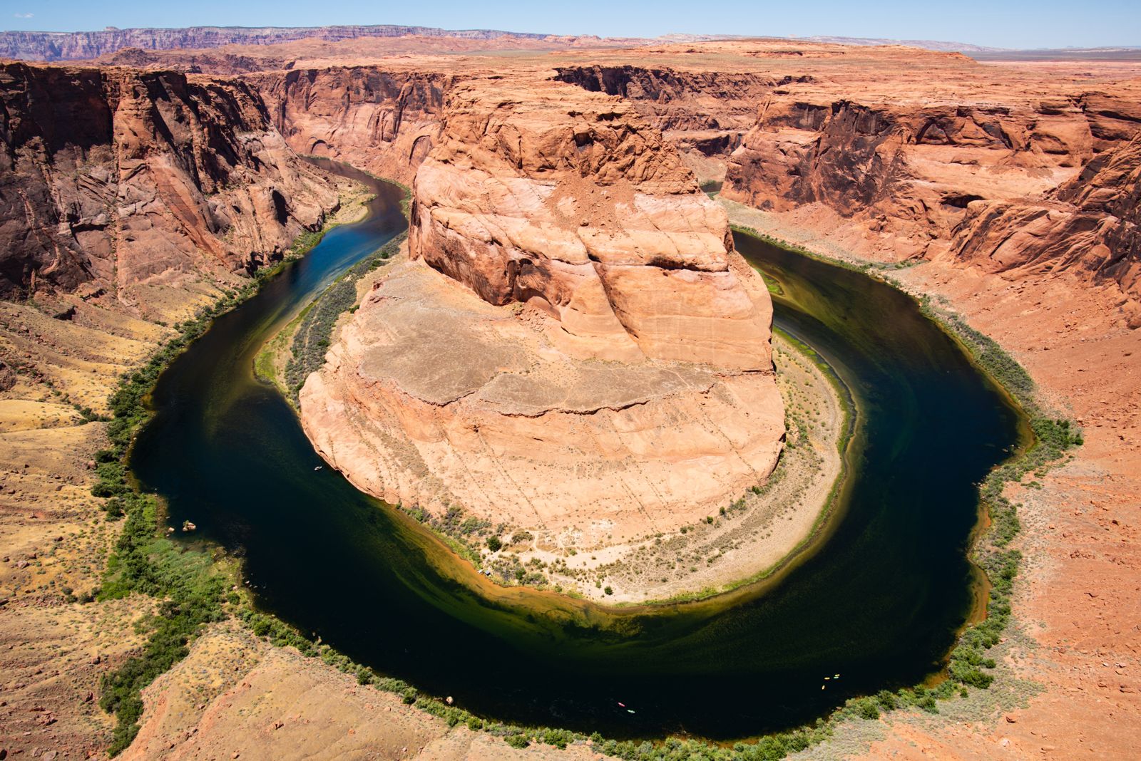
Horseshoe Bend is a loop of the Colorado River just south of Page, Arizona, where the river swings around a sandstone escarpment in a curve the National Park Service describes as roughly 1,000 ft (305 m) deep and 270 degrees around. You see it from a single overlook at the end of a 1.5-mile round-trip trail. There is no ticket and no guide, only a parking fee of $10 per car, collected by the City of Page.
It is the natural partner to Antelope Canyon. The two sit on either side of Page, about 15 minutes apart by car, and they are opposites in almost every way: one is a wide-open view from a cliff top that you walk to on your own, the other a narrow slot on Navajo land that you can only enter with a Navajo guide. Most visitors to Page see both in the same day. Below: how the bend formed, who runs what, the trail and its rules, when the light is best, and how to fit it around a canyon tour.
Horseshoe Bend at a glance
The figures below come from the National Park Service and the City of Page, which share the site.
| Where | Off US Highway 89, between mile markers 545 and 544, about 5 miles (8 km) south of Page |
| The view | A curve of the Colorado River about 1,000 ft (305 m) deep and 270 degrees around |
| Trail | 1.5 miles (2.4 km) round trip, 137 feet of elevation gain, rated moderate |
| Time on the trail | About 20 minutes each way |
| Parking | $10 per passenger vehicle, $5 per motorcycle; park passes not accepted |
| Hours | Sunrise to sunset; times may vary |
| Shade | Two shade structures on the trail, none at the overlook |
| Water and toilets | None on the trail; toilets at the parking lot |
| Visitors | More than 1,422,000 in 2023, by the City of Page’s count |
How the river carved a horseshoe
Horseshoe Bend is what geologists call an entrenched, or incised, meander. The Park Service explains it in a few lines. On its long journey to the sea the Colorado River wandered across a fairly flat landscape, making wide bends and always following the path of least resistance. Then, around 5 million years ago, the Colorado Plateau began to rise. The meandering rivers that crossed it were trapped in their beds, and as the land kept rising they cut straight down through the uplifted layers of sandstone instead of shifting sideways.
The result is a loop that has kept its old, lazy shape while sinking deep into rock. At Horseshoe Bend the river runs about 1,000 ft (305 m) below the rim and turns roughly 270 degrees around a tall sandstone fin before heading south again. The City of Page describes the same thing from the visitor’s side: you stand at an overlook above a drop of about 1,000 feet and look down on the river winding through red-hued sandstone.
It is a different process from the one that made Antelope Canyon. The slot canyons near Page were cut by flash floods tearing through soft Navajo Sandstone from above. Horseshoe Bend was made by a large, permanent river slowly sawing downward as the land rose beneath it. Seeing both in a day shows two very different ways water shapes the same desert.
Who looks after it
Horseshoe Bend is a good example of how tangled land ownership is around Page. According to the National Park Service:
- The bend and that stretch of the river are part of Glen Canyon National Recreation Area.
- Grand Canyon National Park begins about nine miles downstream, which is why the bend sometimes appears in Grand Canyon material.
- The parking area and trailhead, US Highway 89 and the land north of the trail halfway to the overlook are in the City of Page.
- The land south of the parking area, including the trail and the overlook itself, is on the Navajo Nation.
The practical upshot is that three different authorities set the rules you meet on one short walk. The city runs the parking lot and collects the fee. The Park Service manages the river and the recreation area, which is why its drone rules apply. And the City of Page states plainly that this is not a Navajo Tribal Park, so the Navajo entry fee you pay at Antelope Canyon does not apply here either.
Getting there
From Page, head south on Highway 89 for about 5 miles. The Park Service places the parking lot and trailhead between mile markers 545 and 544, and the City of Page says the turnoff is well marked. Lower Antelope Canyon, on the other side of town, is less than 10 minutes from Page going east on Highway 98, which is why the two are so easy to combine.
A few rules matter before you arrive:
- No roadside parking. Highway 89 is a 65 mph highway, and the City of Page says vehicles parked anywhere along it are ticketed and towed.
- No drop-offs. A city emergency ordinance prohibits dropping off or picking up passengers at the Horseshoe Bend entrance or along the Highway 89 corridor, so you cannot have someone wait on the road while you walk.
- Shuttles on busy days. A Lower Antelope Canyon operator notes that on holidays and busy weekends the city may require visitors to use a shuttle once the lot fills.
The lot itself was expanded in early June 2019, with a separate area for larger RVs, accessible spaces near the trailhead and angled bays for commercial vans and buses. If you are coming without a car, our guide to getting to Antelope Canyon from Las Vegas, Phoenix and Page covers the drive, the flights into Page and the day tours that include Horseshoe Bend.
Parking fees
Horseshoe Bend has no entry ticket. What you pay is a parking fee set by the City of Page. Its current list:
- Motorcycle: $5
- Passenger vehicle, including any car, truck or RV: $10
- Van or bus up to 14 people: $35
- Van or bus for 15 to 35 people: $70
- Bus over 35 people: $140
The city takes both cash and cards, with no discounts and no refunds. Two points catch people out. First, the National Park Service confirms that America the Beautiful and other park passes do not apply, because the lot is on city land. Second, the Park Service’s own entrance fee for Glen Canyon, $30 per week per passenger vehicle, is a separate charge for the recreation area, which you meet at places such as the Lake Powell launch ramps; a Glen Canyon pass does not cover the parking here.
The trail
The walk to the overlook is short and easy to follow. The Park Service describes a hardened path 1.5 miles (2.4 km) round trip that is accessible under the Architectural Barriers Act. The City of Page adds that it is relatively flat packed dirt with 137 feet of elevation gain, rated moderate, and that it takes about 20 minutes to walk each way. Wheelchairs, strollers and leashed dogs are all welcome on it.
The main challenge is exposure, not distance:
- Little shade. There are two shade structures along the trail and none at the overlook.
- No water. There is no water anywhere on the trail; carry your own.
- No toilets. Use the ones in the parking lot before you set out.
- Heat. The city warns that summer temperatures can exceed 100°F (37°C), and both it and the Park Service advise avoiding the hottest part of the day.
- Hot ground. If you bring a dog, mind its paws; the city notes the ground can be hot enough to burn, and pets should never be left in a vehicle.
No drones, bikes, skateboards or motorized vehicles are allowed on the trail. In an emergency, both the Park Service and the city say to call 911.
At the overlook
In 2018 the city built a fenced overlook area, and the Park Service says the viewing platform has railings. Beyond that, the rim is open. Much of it remains exposed to the 1,000-foot drop, and the city warns that the sandstone edges can be unstable and break or slide underfoot. Keep children close, keep dogs on a short leash, and resist stepping out onto ledges for a photograph.
The Park Service notes one more rule here: launching, landing or flying a drone on lands and waters it manages in Glen Canyon National Recreation Area is prohibited unless the superintendent approves it in writing. That covers the bend and the river below.
When to go
Horseshoe Bend is open from sunrise to sunset, according to the city, though it notes the times may vary. The view works at any hour, but the light and the crowds change a great deal through the day.
- Morning. A tour operator that runs trips from the Horseshoe Bend area says the light tends to be more yellow, orange and bright in the morning. Sunrise is the quietest time at the overlook, with cool air and room along the rim.
- Midday. The hardest time to be on the trail from late spring to early fall, with little shade and strong sun. Bring more water than you think you need.
- Afternoon and sunset. The same operator says the light is more red and magenta in the afternoon. A Lower Antelope Canyon operator calls sunset the busiest hour at the overlook.
Through the year, the pattern follows the rest of the Page area: hot summers, cold winter mornings and comfortable spring and fall days. Our Antelope Canyon weather guide sets out what each season means for both places, including the summer monsoon.
Horseshoe Bend and Antelope Canyon in one day
The two are separate places with different rules, and they combine easily. A Lower Antelope Canyon operator puts them about 15 minutes apart on either side of Page and suggests allowing about an hour for Horseshoe Bend. Its own canyon tours run 60 to 90 minutes, after a check-in 45 minutes before the tour time.
The one part that needs planning is the canyon. Horseshoe Bend needs no reservation, while the Navajo parks department says tour guides are mandatory in Antelope Canyon, and the popular tour times fill up. Book the canyon first and fit the overlook around it:
- Early start. Horseshoe Bend at sunrise, breakfast in Page, then a morning canyon tour.
- Afternoon tour. A canyon tour around midday, then Horseshoe Bend in the late afternoon or at sunset if you do not mind company.
- Passing through. Coming up Highway 89 from Flagstaff or the Grand Canyon, the overlook is on your way into Page and makes a natural first stop.
Leave a buffer: the canyon check-in is strict, and missing a paid tour slot is the most expensive mistake in Page. If you have not chosen a canyon yet, our comparison of Upper, Lower, Canyon X, Secret Canyon and the kayak route sets out the differences.
The time-zone catch
Horseshoe Bend keeps Arizona time, the same as Page, Phoenix and Flagstaff. The Navajo Nation, whose land starts just outside town, observes daylight saving time; Arizona does not. From March to early November, Page is one hour behind its neighbors in Utah and on the Navajo Nation, and phones that pick up a tower across the line can jump an hour ahead without warning.
Antelope Canyon operators run on Mountain Standard Time all year, the same as Page. So a sunset at the overlook and a canyon tour time are both on the same clock, but your phone may not be. Set it to Phoenix time while you are in the area, or check the local time in Page before you plan the day.
Secret Antelope Canyon, next door
The Navajo parks department lists the upper part of East Waterholes as reachable by guided tours only, and names Horseshoe Bend Slot Canyon Tours as the operator. That operator sells it as Secret Antelope Canyon, a slot that is part of the wider Antelope Canyon system but separate from Upper and Lower, about 4 to 5 miles from them.
Its tours leave from just down the road from the overlook. The operator gives the starting point as 3 miles south of Page on US-89 and 0.4 miles south of the Horseshoe Bend Overlook. The tour lasts about 2 hours: a 4x4 drive of about 6 miles, roughly 30 minutes, across Navajo land, then an easy, flat walk of about 300 meters to the mouth of the slot, with a three-quarter-mile round-trip walk in all and no ladders. Tickets are listed at $110 for ages 6 and up, and children under 6 are not taken.
Because both leave from the same stretch of Highway 89, Secret Antelope Canyon and the overlook fit together in a single morning or afternoon. The operator is candid about light beams there: they appear only for short spells in spring and fall and last about 30 minutes in the late morning, so do not book it for beams.
The lower part of East Waterholes is different again. The parks department says it needs a Navajo backcountry permit, sold for $15 per person at any Navajo Tribal Park location, and lies just off Highway 89 at milepost 542.
Seeing the bend from the river
The overlook is not the only way to see Horseshoe Bend. The Colorado River below Glen Canyon Dam runs past it to Lees Ferry, and the Park Service describes a well-used paddling route. There is no put-in at the dam, so kayakers launch at the Lees Ferry ramp and arrange a tow upstream, by a friend’s motorboat or a backhaul service, then float back down through the canyon and around the bend.
What the Park Service asks of paddlers:
- A free backcountry river permit, filled out at the launch ramp.
- A Coast Guard approved lifejacket, worn while underway by everyone in a hand-propelled craft between the dam and the Grand Canyon boundary.
- Pack it out. There are five camping areas along the river, first-come, first-served, with grill pits and vault toilets but no trash cans.
Lees Ferry is 43 miles by road from Page, about 50 minutes, so a river day is a full day. Water flows depend on releases from the dam, so the float can be gentle or brisk.
Is Horseshoe Bend worth it?
For most visitors to Page, yes, and the reason is the ratio of effort to reward. It costs $10 for the car, takes about an hour door to door from the lot, and needs no booking. The view, a deep loop of river in a ring of red rock, is one of the most recognizable in the American Southwest, which is also why more than 1,422,000 people came in 2023.
The downsides are crowds and heat. At sunset you share the rim with a great many people, and in high summer the walk back to the car can be hard work. Go early, carry water, and you will have the better experience.
It also gives you something Antelope Canyon cannot: space. After the narrow, guided passages of a slot canyon, standing on an open rim above the Colorado River is a welcome contrast. If you have time for only one more stop in Page beyond the canyon, the overlook is the obvious choice; if you have a full day, our piece on Lake Powell covers the lake end of Antelope Canyon, the dam and the boat and kayak trips.
Frequently asked questions
Do you need a ticket or reservation for Horseshoe Bend?
No. There is no ticket and no reservation. You pay a parking fee to the City of Page, $10 for a passenger vehicle or $5 for a motorcycle, and walk out on your own.
Does a national park pass cover Horseshoe Bend?
No. The bend is in Glen Canyon National Recreation Area, but the parking lot is on city land. Both the Park Service and the City of Page say America the Beautiful and Glen Canyon passes are not accepted for parking.
How long is the Horseshoe Bend hike?
The trail is 1.5 miles (2.4 km) round trip with 137 feet of elevation gain. The city says it takes about 20 minutes each way; allow about an hour in all with time at the rim.
Is there a railing at Horseshoe Bend?
There is a fenced overlook area, built in 2018, with railings on the viewing platform. Much of the rest of the rim is open to the 1,000-foot drop, and the sandstone edges can be unstable.
How far is Horseshoe Bend from Antelope Canyon?
About 15 minutes by car. Horseshoe Bend is about 5 miles south of Page on Highway 89, and Lower Antelope Canyon is less than 10 minutes east of Page on Highway 98.